Overview The 25-day Tsum Valley Manaslu Circuit Trek is a complete deep-dive loop that bridges two of Nepal’s most distinct restricted trekking regions. By extending the classic circuit to nearly […]
Duration: 25 Days
Best Time:
Trip Grade: moderate
Start from Kathmandu and End to Kathmandu
Min 2 to Max 15 Pax in a group
Meals: Breakfast, Lunch, and Dinner
Accommodation: Tea House
Overview
The 25-day Tsum Valley Manaslu Circuit Trek is a complete deep-dive loop that bridges two of Nepal’s most distinct restricted trekking regions.
By extending the classic circuit to nearly four weeks, this itinerary allows you to break away from the main transit trail to explore the isolated Tibetan-influenced Borderlands of the upper and lower Tsum regions before returning to the complete high-altitude geographical loop around Mount Manaslu (8,163m).
The trail acts as a physical and environmental transition, moving from the low, humid subtropical canyons of the Budhi-Gandaki River into the ancient stone monasteries of Tsum, and finally ascending beneath the massive glaciers of Nubri Valley to cross the strenuous, high altitude Larkya La Pass (5,106m).
This is a 25-day timeframe that provides the most practical and safe pacing available for the combined route, offering a natural acclimatisation profile that builds the physical stamina needed to handle the back-to-back trail days without rushing to the remote communities.
Trip highlights
Wherever we go, our major purpose is to visit that place for a new experience and to learn about a new culture, and majorly visual highlights, and the combination of the Tsum Valley and Manaslu is what gives you the true magic of the trip.
Let’s uncover these standout highlights that make this specific combined route very special and legendary.
The time capsule of isolated Tsum Valley
So basically, when we think of a time capsule, what comes in front of your eyes? Prolly something like that’s been preserved in a box or locker or like an artefact frozen in ice out of time, isn’t it?
Just like that, the Tsum valley feels out of time, like frozen and unaffected by the fabric of time and space. Something so typical and primitive, as if the whole world moved ahead, but this place just stood there intact.
It’s isolated, and one of the reasons for that was its restrictions for foreigners until the year 2008, also known as (Beyul Kyimolung- The hidden valley of happiness), remains culturally pristine and untouched.
We will be trekking all the way to Mu Gompa (3,700m), a remote monastery sitting at the literal geographic dead end of the valley near the Tibetan border, where you can hear the deep drone of monastic horns echoing against the bare rock walls.
We’ll also be exploring the Rachen Gompa, the sacred cliffside meditation caves of St Milareapa, where the ancient Buddhist murals and hundreds of thousands of hand-carved mani stones line the trails. This site has unparalleled peace. Unlike the busier main circuit, the Tsum detour feels totally off the grid, the traditional slate-roofed for villages and authentic homestays.
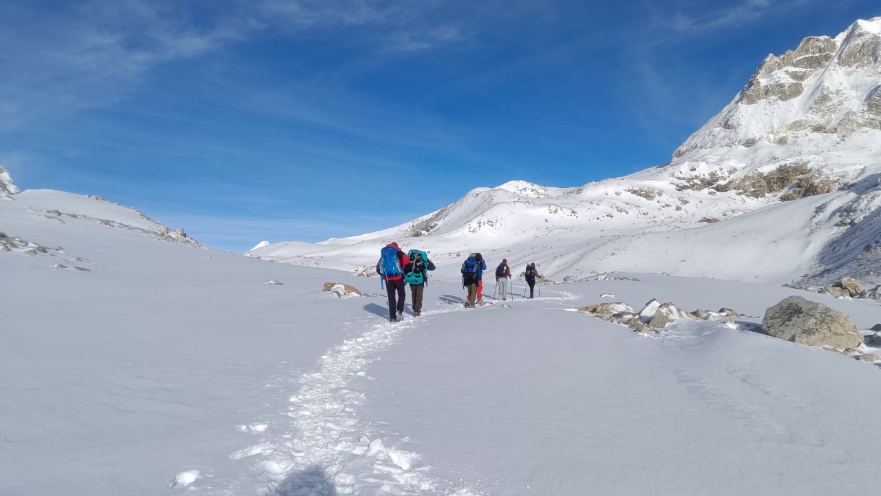
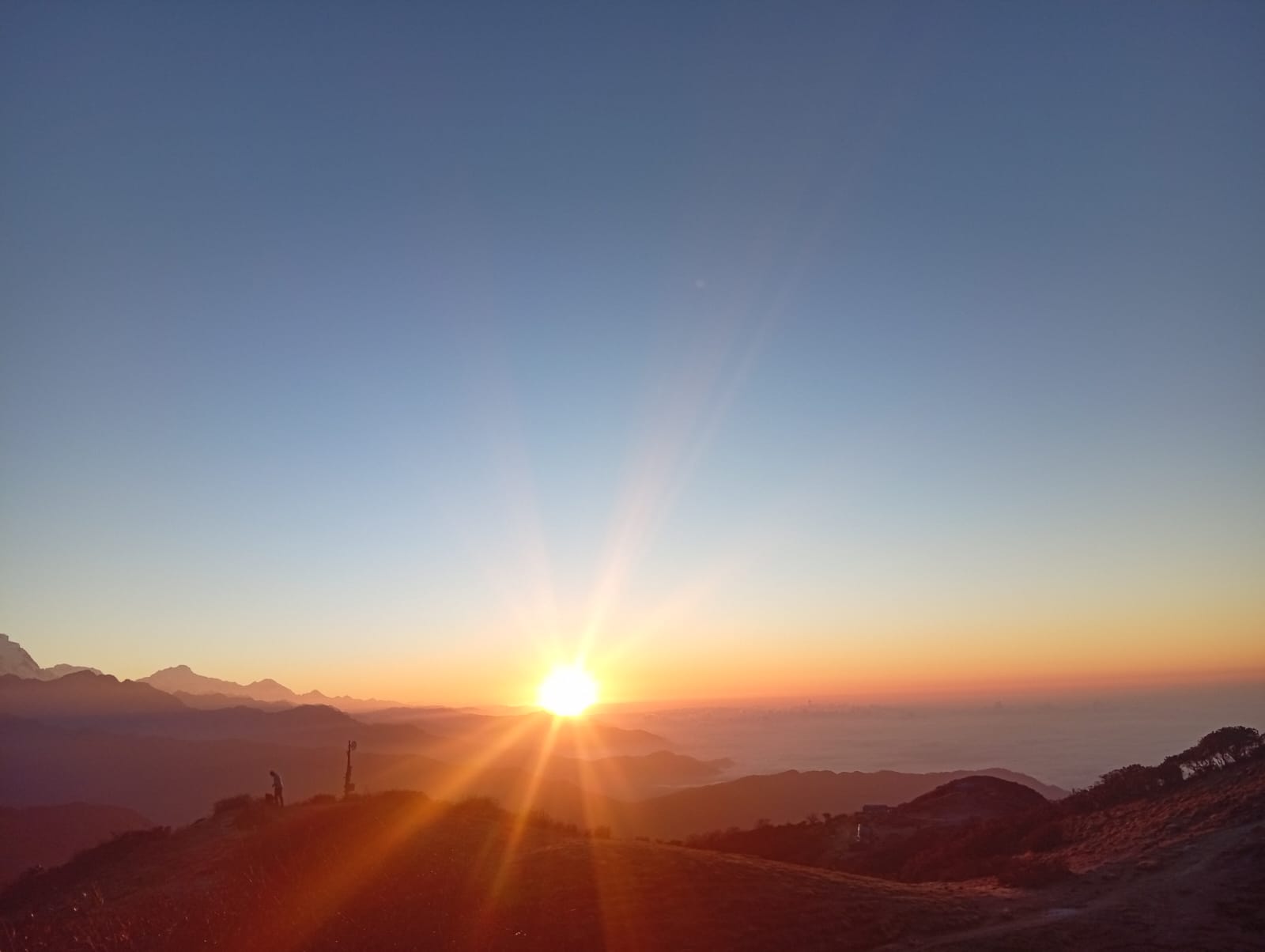
Conquering the Larkya La Pass (5,106m)
The point of attraction of the trip and the ultimate test is the highest geographical point of the entire 25-day trip. It is a challenge that begins at 3:00 AM as you leave the frozen stone shelter of Dharmasala under a brilliant blanket of high-altitude stars, fighting the thin, biting air to push your legs up the dark moraine. The Low-Altitude River Canyons & Thermal Springs Considerably prior to reaching the frozen snowfields and glaciers, the initial stage of the journey delivers a rough, wilderness-style experience tracking the profound, sheer path of the Budhi Gandaki River. The route is characterized by striking topography where you trek across massive, metal cable suspension spans covered with religious banners, dangling vast distances over churning torrents. On the fourth day, the track routes through the miniature outpost of Tatopani, renowned for its organic geothermal waters flowing directly out of the rockface. Pausing at this spot to immerse your limbs in the boiling, nutrient-dense geological flow is a traditional custom, cleansing away the dirt from the trail and re-energizing your physical frame before you confront the unforgiving rocky steps furthur up.
A close and intimate experience with the Tibetan Nubri heritage.
The social aspect of this journey transitions entirely as you climb, moving from Lowland Hindu, agrarian communities to Alpine Tibetan Buddhist settlements where populations exist in a balance with the unforgiving climate.
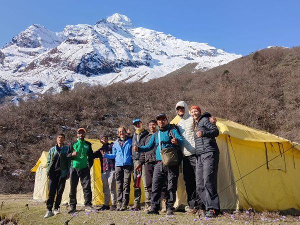
You are not merely traversing an area; you are tracking through a continuous heritage, passing immense multi-meter stone alignments constructed from thousands of separate eastern blocks. Precisely, she served with holy inscription across generations. Nights are incredibly genuine, spent gathered around metal hearths within classic rock tea-houses, consuming warm, savoury dairy tea or native grain beer while discovering the distinct ancestral customs from the mountain residence.
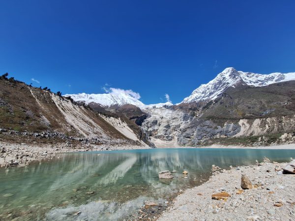
The high altitude glacial structures
The geography surrounding the upper loop is bordered by cold, quiet reservoirs supplied straight by the dissolving faces of snow hanging vast vertical distances above the trail.
The most iconic of these formations is Birendra Lake, 3,450m, a remarkable emerald-toned basin located precisely at the base of Manaslu’s primary glacial drop. It is a straightforward, magnificent excursion out of somewhere where you can rest on the gravelly, icy bank, toss pebbles across the mountain water, and securely observe, snow-slides cascading down the far summits into the lower rock valleys.
Upon reaching the peak, the reward is instant and overwhelming. When you find yourself standing among the Hundreds of snapping ice-coated prayer flags with an unobstructed panoramic view of several peaks like Himlung Himal (7,126m), Kang Guru, and the massive walls of Annapurna II is what follows the burning descent down the loose gravel and glacial ridges that drops you straight into the spectacular green forest basin of Bhimtang.
The low-altitude river canyons and thermal springs.
Considerably before reaching the frozen snow-fields, the initial stage of the journey, they diversified Rottweiler and system experience tracking the profundity of the Budhi Gandaki River. The route is characterized by striking topography where you traverse massive metal cable suspension spans covered with religious banners dangling vast distances over churning torrents.
On the 4th day, the track routes through the miniature outpost of Tatapani, renowned for its organic geothermal waters flowing directly out of the rock face. Pausing at this stop to immerse your limbs in the boiling, nutrient-dense geological flow is a traditional custom. cleansing away the dirt from the trail and reenergizing your physical frame before you confront the unforgiving rocky steps farther u
Elevation, caution, logistics and insurance.
Altitude profiles and key milestones.
During these 25 days of combined itinerary, you need to be very careful regarding altitude management cause there’s gonna be ups and downs, not just ups and downs, but the toll on your body mentally, physically, psychologically, with every step.
Typically, what happens is that the elevation sickness or its symptoms get detected around the elevation of 2,500 meters, and we will be. Reaching up to the elevation level of around 5100m, where the oxygen level is significantly thinner than imagined, and the atmospheric pressure is way higher than you can imagine.
Moreover, the script flips if you’re someone from the lowlands as the immense pressure of mountain exerts high pressure on the body of lowlanders who have not had proper cardio endurance training and exercise along with the preparation for acclimatization And also, as the journey forces you to spend multiple consecutive days sleeping over 3500m in both the Tsum Valley and Upper Nubri region, understanding the exact height profile of your overnight stops is critical.
Strategy for Acclimatisation
It requires proper calculated strategy in order to acclimatise well and avoid the possible Health issues that might arise due to risen altitude. One of the most important strategies for those is the rule of “Climb high, sleep low, which simply means. During the daylight, you climb to the highest point possible and then return to the base for the overnight stay.
This way, the Biology of your body adapts to the changed altitude and prepares you with more amount of red blood cells in your body for oxygen supply,y and also to deal with the altitude you will climb the next day and help you ease and deal with the issues and symptoms of altitude sickness.
Above the 3000m threshold, you must strictly limit your net sleeping elevation gain to no more than 300 to 500 meters per 24-hour period, ensuring that you schedule a mandatory rest day for every 1,000 meters of elevation gain. And the most important step to undertake is proper exercise time and again, as this helps your body to maintain its composure and regulate the blood and oxygen supply in every part and cell of your body at high altitudes while maintaining your body temperature.
Identifying the Acute Mountain Sickness.
Pay close attention to yourself and fellow trekkers if you are trekking in a group or solo, in order to identify the initial symptoms of acute mountain sickness.
The basic symptoms include weakness and dizziness. Throbbing headache, loss of appetite, dry cough, loss of balance or mental confusion, or even loss of consciousness are some of the symptoms that can escalate rapidly into a life-threatening situation during high-altitude emergencies. Even if the minor symptoms appear like this, the absolute protocol is to stop immediately, get some medical attention if possible or rest for a while, then gently descend, as staying at a high altitude for a long time can worsen the situation, but also do not descend rapidly, as it puts more stress on your body and worsens the situation further.
To deal with the sickness:
Maintain a steady level of water consumption and temperature regulation if it shows symptoms. And to avoid it, follow simple rules and guidelines, such as avoiding the trip on an empty stomach or in a state of intoxication. If you are a bit distant from the group, then as soon as you start to feel the symptoms, inform the person nearest to you, and in case of a severe condition, helicopter evacuation is the only option, even if it means right in the middle of the night.
Negative weather and environmental Hazards.
Beyond the teenager, the extreme high Alpine environment introduces several weather risks like hypothermia and dehydration that can quickly compromise your safety. Nighttime temperatures at the high altitude camps can plummet below freezing point, which requires you to wear proper layering of clothing in order to preserve the heat of your body. Use a proper layer of moisture-wicking base, insulating fleece, middle and heavy windproof shell to lock your body heat.
Furthermore, because the freezing, arid air causes you to lose moisture rapidly simply by breathing, you must constantly monitor your water intake, while simultaneously protecting your eyes and skin with polarised sunglasses and high-factor sunblock to combat the blinding solar radiation reflecting off the snow fields of the pass.
The insurance
Mandatory mountain insurance specifications.
Usually, for regular mainstream trekking, regular policies can cover the cost and altitude, but for this trekking trip, regular insurance does not cover the cost. This is why you will need a policy that explicitly covers the helicopter evacuation up to an altitude of 5,500m. In case of severe altitude sickness at Dharmasala or Larkya Phedi, a place where there are no roads for the land transportation system, helicopter evacuation is the only resort, so during your insurance policy negotiation.
You must explicitly mention and look for the policy that covers the helicopter evacuation for your own safety, and also make sure that the provider operates on a direct billing basis with Heli rescue service, so you are not obliged to pay thousands of dollars in cash up front during a medical emergency.
Logistics management
The cash crunch: Cash is king during the trip, as there is no use of online payment or QR scanning during the trip, as the weather might. Influence the connection and internet payment method negatively, which is why you are recommended to have enough stock of cash for the payment at the different points of service in order to easily transaction flow.
For services like hot showers, battery charging, Wi-fi, you need to pay all those charges on a cash basis, so you are advised to carry at least NPR 40,000 to 50,000 in cash with different denominations to make the transaction smoother for petty expenses.
No plastic zone: Tsum is considered a sacred beyul ( Valley of Peace). The native communities strictly prohibit single-use plastic water bottles as they contribute to the Rise in waste quantity. As a result, it’s advised for travellers to use reusable water flasks or water purification tablets/filters (like Sawyer Squeeze).
Food and Water Reality
When you are out in the wild for 25 days, your fuel is everything. The menus across the Manaslu Circuit and Tsum Valley transition significantly depending on your altitude and how remote the village is.
The power of Dal Bhat: In the lower elevations. You will find the standard Teahouse menus offering pasta, pancakes and eggs. However, as you climb higher past the 3000m into the Tsum Valley and Upper Nubri, Dal Bhat (Rice, lentils and vegetable Curry) becomes the non negotiable stable. This is Fresh calorie, dense and cooked daily, and crucially, it comes with free refills to replenish your energy after a 7-hour walk.
The meat rule: The region is a Buddhist majority. Slaughtering animals is strictly forbidden. Any meat available in high-altitude teahouse has been carried up on a Porter’s back or mules from the lower valleys for several days without refrigeration. The rule is simple: Stay strictly vegetarian above Jagat to avoid debilitating stomach bugs.
Hydration strategy: To combat altitude sickness, you need to consume 4 to 5 litres of water daily. Since plastic bottles are banned in the valley, you must rely on tap water or mountain streams, and also never forget to treat the water with purification tablets are high-quality filter pump before drinking it.
Communication, Internet and power supply.
While on trial, staying updated and in touch with friends, family and your necessary people is one of the very vital acts for safety, security, assurance and communication. And in a long trip like this that goes over 3 weeks, the loop requires a realistic understanding of the local infrastructure. So do not expect stable or very high-efficiency connections on the trail.
Network coverage: Nepal has two major network providers, these being Ncell and Nepal Telecom (NTC). Ncell provides a decent data coverage in the lower river valleys, while NTC provides better into the high altitude Pockets of the Manaslu circuit and is preferred by the majority of trekkers in different regions. However, when you get into the deep gorge valley, both networks gradually start to fade entirely into the dead zones for days at a time.
Satellite WI Fi: Many tea houses on the circuit now offer Everest Link or local satellite WI-Fi card systems. These are not free, as you must extract or purchase a data card for roughly $3 to $5, and the speed is highly weather-dependent due to the high altitude, which is obvious, and is only sufficient for basic tasks like text messaging.
The premium power: Many remote tea houses run entirely on the local micro hydropower or solar power setups. Powering your devices like phones, batteries or cameras, or power banks, incurs an extra charge or fee that increases with elevation, ranging from NPR 200 to NPR 500 per charge.
Trail safety, Landslide zones and Rockfall hazards.
You’re a mountainous nation, walking beside a mountainous trail. The topography is very highly volatile and is constantly shifting, which requires you to be very aware of the active geological hazards along the trail.
The Khorlabesi to Jagat stretch: The Lower Canyon section features steep vertical rock faces that are highly prone to certain stone drops and active landslides, particularly after heavy rainfall or during the spring melts.
Safety protocol: While traversing a marked landslide zone, never stop to rest, take photos or look at your phone. Keep your eyes up on the Cliff above you. Using your backpack straps so you can drop your backpack quickly if needed and listen to the distinct crack of the tumbling rocks. Before a guide tells you to move quickly, do not hesitate; cross the exposed sections one by one with ample space between trekkers.
Arrive at Kathmandu Airport and transfer to the hotel.
—
02
Kathmandu Valley sightseeing tour and document preparation.
Full day
03
Drive from Kathmandu to Machhakhola (870m).
7–8 hrs
04
Trek to Jagat (1,340m).
6–7 hrs
05
Trek to Lokpa (2,240m).
6–7 hrs
06
Trek to Chumling (2,386m) – Lower Tsum Valley.
5–6 hrs
07
Trek to Chhokangparo (3,010m) – Upper Tsum Valley.
5–6 hrs
08
Trek to Nile (3,361m) and continue to Mu Gompa (3,700m).
6–7 hrs
09
Explore Mu Gompa and return to Chhokangparo (3,010m).
5–6 hrs
10
Trek from Chhokangparo to Gumba Lungdang (3,200m).
6 hrs
11
Trek from Gumba Lungdang to Ganesh Himal Base Camp (3,850m).
6 hrs
12
Exploration day at Ganesh Himal Base Camp.
Full day
13
Trek from Ganesh Himal Base Camp to Ranjam.
6 hrs
14
Trek back to Lokpa (2,240m).
6–7 hrs
15
Trek to Bihi Village (2,100m).
6–7 hrs
16
Trek to Namrung (2,630m).
6 hrs
17
Trek to Shyala Village (3,500m).
6–7 hrs
18
Acclimatization day with hike to Pungyen Gompa (4,040m) via Samagaun.
5–6 hrs
19
Explore Birendra Lake and rest at Samagaun.
Full day
20
Trek to Samdo (3,860m).
3–4 hrs
21
Trek to Dharamsala / Larkya Phedi (4,460m).
4–5 hrs
22
Cross Larke La Pass (5,106m) and descend to Bhimtang (3,720m).
8–9 hrs
23
Trek to Dharapani (1,860m).
6–7 hrs
24
Drive from Dharapani back to Kathmandu.
8–9 hrs
25
Transfer to the international airport for your departure flight home.
—
Itinerary
If you want tailor-made trip or want to personalize this itinerary, just feel free to contact us. We are always there to help you to make your holiday plan. Contact us
Day 01
Arrived at Kathmandu Airport, transferred to the hotel.
When you arrive at Tribhuvan International Airport, Kathmandu, you’ll be received by a member of the agency and driven to your hotel. You’ll have time to freshen up, change and have some snacks. Over time, your guiding crew will be in the office to have a talk with you regarding the transactions and any queries.
Day 02
Kathmandu Valley tour and document preparation.
The capital is a fascinating place, with surroundings full of heritage and ancient arts.
Even though somewhere unmanaged and chaotic, that's what really makes the city unique, full of architecture belonging to a variety of communities and groups blended in one place and harmony, giving a beautiful message to the world.
You’ll start from the Kathmandu/Hanuman Dhoka Durbar Square, followed by several other world heritage sites like Bouddhanath and Swyambhunath.
The day goes like this, exploring sites and maybe trying local delicacies or sharing stories with old folks in the neighbourhood.
In a sense, the day will be worth it, and by the time you get back, your necessary paperwork will have been made ready by the office.
Day 03
Drive from Kathmandu to Machhakhola (870m) – 7-8 hours
We start our trip following breakfast at the hotel, and afterwards we board the bus to Machhakhola. The trip will be around 7-8 hours at least.
The distance is around 160 km, but don't be naive enough to think it's short regarding the trip.
You’ll obviously have a trip that's a blend of adventure, thrill and drama as the first half of the trip treats you with a visual feast of beautiful rivers and valleys.
As you get past Dhadingbesi and head towards Arughat, the real Himalayan off-road trip starts as the pitch road darts, fades, and it’s all the jagged road that is on the way along the Budhi Gandaki river before finally stopping at Arughat.
Day 04
Trek to Jagat (1,340m) – 6-7 hours
It was a trip on wheels till yesterday, but from today we’ll be on foot.
We'll start our trip by tracking the Budhi Gandaki River as it crosses dense forests and subtropical lands.
The morning will be a thrilling experience and an introduction to deep, roaring gorges and cliffside. The swaying suspension bridges, too, are highlights in themselves.
We’ll pass through Khoralbesi and then get to Tatopani. This place is known for its natural hot spring source of water that spouts right out of the cliff.
The best thing is that you can get to soak yourself and get relieved of all the weariness and fatigue from the trip, and get more energised for the trip ahead, as the trail is filled with a rugged staircase of stones. As the afternoon approaches, the valley finally reveals the stone-paved village of Jagat, which is the official entry point of the restricted area of the Manaslu region.
Day 05
Trek to Lokpa (2,240m) – 6-7 hours
Time to head for the next destination, and it’s time for Lokpa. We’ll walk around for almost half a day and also rise in elevation from 1,300m to the range of 2,200m, and we do it steadily, because while inclining, if we rush, our bodies might get fatigued very fast and easily.
We’ll maintain a steady pace alongside the river.
The trail takes us through the small village of Salleri before we descend towards the wider route of Philim, with a beautiful terrace, fields of rice and maize, which is surrounded by towers and rock walls.
One of the real magical moments happens when we officially separate from the Manaslu Circuit and enter the Narrow Wild, deeply mystical after crossing the suspension bridge, and finally get to the Tsum Valley.
The terrain becomes much steeper, more rugged, and more relentless going through the pine forests.
Day 06
Trek to Chumling (2,386m, Lower Tsum) – 5-6 hours
As the days go by, higher we go and the higher we go, the deeper we step into the Tsum Valley.
This is a shorter day comparatively, but the ascent is what makes it feel tough on the body and a long day at work, so what you gotta do is keep a strong mindset during the walk.
From diving into the narrow canyons and crossing suspension bridges above Shair Khola with emerald water below our feet, from bamboo and rhododendron forests to narrow paths embraced by cliffs, the trip today is one of a one-of-a-kind experience of life.
And at the end of the day, when the forest thins out, the snow-capped view of the mountain bursts into view with the faint scent of Juniper and pine trees, along with visuals of Mani walls in front of you.
By the afternoon, when you complete the ascent and arrive at Chumling, you’ll be rewarded with a beautiful view of the Buddhist village.
Day 07
Trek to Chhokangparo (3,010m, Upper Tsum) – 5-6 hours
We’ll cross a suspension bridge over the Shair Khola, and the rail takes us by the village of Ranjam; it’s a beautiful sight to see. We head deeper into the sacred, hidden valley, tackling steep and challenging climbs through the pine and rhododendron forest.
You might feel strange that the majority of the trail is filled with Rhododendron, Pine and Juniper, but that’s what high-altitude is filled with, and these kinda plants make it there.
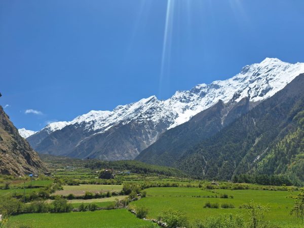
The higher we go, the vegetation starts to fade away and gradually opens up to the wide, flat valley. Just like the day before, the plain today also reveals the terraced fields and traditional stone-roofed house. The peaks of the Ganesh Himal range line the horizon as if they are guarding the plains.
By the time it’s afternoon, we’ll be at Chhokangparo, it’s a beautiful village with a blend of culture and serenity of high mountains.
Day 08
Trek to Nile (3,361m), continue to Mu Gompa (3,700m) - 6-7 hours
Day 8 is like a very climax of the Tsum Valley Manaslu Trek, going from the highest point and ultimate geographic dead-end of the trek near the Tibetan border.
We start by stepping into a wide trail of the Upper Tsum, walking past the sacred cliffside cave of St. Milarepa. The path gently rises along the flat, windswept plains, lined with the long Mani walls in the region. We pass through the Tweeny villages of Phurbe and Pangdun, watching locals tend to their high-altitude crops. By midday, we will visit Nile, the last inhabited village in the Upper valley, divided by a rushing river.
We will be leaving our heavy packs behind and pushing onward and upward into the stark, barren Himalayan landscape. As we move upward, the air grows thinner and crisper. To battle with the thinning air and atmosphere, we will be making a steady incline toward the Tibetan Borderlands.
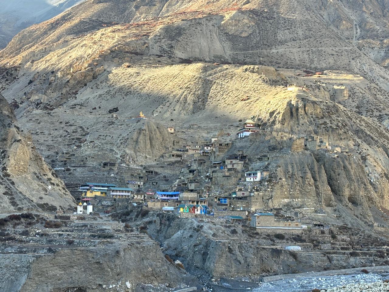
Ahead of us, the massive fortress, like the stone walls of Mu Gompa, will be waiting for us and emerge against a backdrop of snow-capped peaks where we’ll spend the afternoon exploring the ancient monastery standing at the mystical crown of the hidden Valley.
Day 09
Explore Mu Gompa, return to Chhokangparo (3,010m) – 5-6 hours
So, today we’ll explore Mu Gompa for a while. The old prayer halls and friendly monks there really give a glimpse of another dimension of life you might have never tapped into. From the point of Mu Gompa, you can witness the great view over the Tsum Valley. The air is just something cool enough to make your thoughts clear, after which we’ll be heading back to Chhokangparo.
It’ll be a long descent and will require maximum caution, as the trail downwards is much slipperier.
The trip will take around 5-6 hours, of time and you'll be back in Chhokangparo by afternoon with plenty of time to rest, as the descent will have exerted some pressure on the knee and back.
Day 10
Chhokangparo to Gumba Lungdang 6 hrs( 3200m)
From Chhokangparo to Gumba Lungdang, we’ll be trekking up again today. It’ll be a steady and decent walk with a few proper sections of uphill, so no need to worry much.
And as for the remaining portion, the trail drops afterwards through the Pine and rhododendron forest, passes a few small settlements and gets ready for some really good views of the mountain around.
It generally takes kinda 6 hours, depending on how often we stop for a break.
The Gumba Lungdang sits at an altitude of 3,200 meters right below the big peaks, and feels really special and quiet.
By the time you reach Gumba Lungdang it will be afternoon. And you will have enough time to relax and move around.
So even if it is 1/4 of the day, don't panic. Just relax, ok?
Day 11
Gumba lungdang to Ganesh Himal base camp, 6 hrs ( 3,850m)
Moving ahead from Gumba Lungdang to the Ganesh Himal base Camp, it's gonna be a solid day with quite a bit of uphill, gaining a good amount of cold touch of altitude.
The line of trail keeps going across open areas with amazing views of the Ganesh Himal Range, which keeps getting closer.
You can literally feel the chilling and thinning of the atmosphere as the climb progresses. We won't be going all the way to the actual basecamp, but rather just reaching the viewpoint spot around the height of 4,200m.
The mountain, it’ll feel surreal when you stand there, as if it’s right above your head. By the afternoon, we’ll be at camp, and when we're in there, just take your time to rest and recover.
Day 12
Explore the Ganesh Himal base camp trek.
Yesterday it was a six-hour-long climb and an afternoon upon arrival. The body needed rest to recover from the six hours of uphill stride which demanded proper rest and recover so the walk around wasn’t quite properly possible but today since it’s the day for acclimatizing we’ll spend the day in here, walk and hike around the base camp, explore the moraines which will help in adjusting to the surrounding as we’ll try to make it possible highest point before getting back to the valley so our body doesn’t face the pressure of the risen atmosphere the next day.
We’ll prolly be hiking to the Torogumba Glacier. From here, you get amazing close-up views of the Ganesh Himal I (Yangra), Ganesh II, and the surrounding snowy peaks.
The landscape just feels unreal and wildly beautiful, full of rocky ridges, prayer flags and open alpine meadows.
It's just a perfect day to help our bodies adjust to the height before we start backing down to the valley the following day.
No big distances, just gentle exploring and soaking in the mountain scenery.
Day 13
Ganesh Himal base camp to Ranjam-6 hrs
Talking of today, today will be an immediate physical relief. You wake up surrounded by the cold historical walls with the Ganesh Himal range, ready to hit the trail to head down.
No more uphill climbs, just a relentless 6-hour descent that forces you to watch your footing over the loose Alpine gravel scree Trail before the path consolidates into solid dirt.
The landscape starts to change rapidly, obviously because getting down is faster than climbing up, comparatively.
The first couple of hours, well, we will be walking in the barren grey moraine slopes following the path of the glacial meltwater.
As we keep stepping down, the wind decreases by 100 meters, so it will drop, and also the atmosphere gets thicker, and it gets easier to breathe, and the body feels much more alive.
That's something like a stone on the chest kind of experience, which gradually fades away as the oxygen becomes adequate.
On the way in the middle section, the trail goes into old-growth of rhododendron, pine and massive juniper forest. The air suddenly smells like white earth and pine needles, and your lungs will notice the thick surge of oxygen.
Gradually, the second stretch completes, and the final stretch arrives, where you will hit the lower valley floor of this Tsum region, crossing narrow suspension bridges over the rushing waters of Shiar Khola. The wild mountainous roads and trails flatten out into wide, stone-walled corridors built to keep livestock out of the fields.
Day 14
Trek back to Lokpa (2,240m) – 6-7 hours.
Time to wave goodbye to Tsum Valley.
We’ll be starting in the morning. As for the walk, it will be a smooth one and traverse across small Buddhist shrines and stone houses. As for the surroundings, the air will be warm and comfortable. And the path quickly starts to get down into the thick forest tracks.
The further we get, the narrower the valley walls get, and we’ll be in a Deep Canyon where the sunrays are barely reachable and that too for only a few moments of the day.
The path becomes. Sometimes carved directly out of the cliffs' faces. Wait. Steep drops falling straight into the emerald waters of the Shiar Khola below.
Now there's something important you need to know about descending.
Don't think, just because it is descending, it will be faster and easier. The stone step staircases will make your legs shiver by the end of the trip, as it will be one hell of a workout.
Now, you might think descending has ended the trip, but here's the irony: You descend only to climb hundreds of meters vertically back again on the opposite rock wall.
And by the time you push through the final stage of Pine and Bamboo Forest and reach the small ridge settlement of Lokpa your body will have basically given up from the day's effort, and Lokpa is perfect for you to rest and recover as it’s an isolated crucial junction That positions you officially at the exit gate completely preparing you to turn an earth tomorrow and kick off the main loop of the Manaslu circuit.
Day 15
Trek to Bihi village (2100m) – 6-7 hours
So we were on a series of descents and moving further down today, we’ll walk for around 6-7 hours, the trip will be just like other days.
We'll go through a series of damp forests and suspension bridges with an earthly smell.
Once you step on the main trail, the gorge narrows down to a wild, thin canyon that directs us to a vertical cliffside right above the white water.
You will feel breathless, you’ll feel sweaty while you step on the steep rocky staircases up to the stone village of the Deng for a quick lunch.
And just remember to keep hydrating yourself time and again with frequent sips. The afternoon will feel like a classic Himalayan roller coaster, where you will be crossing a few ups and downs time and again before the final relentless wrap-up of the day in the village of Bihi That, which feels incredibly quiet, lined with ancient prayer stones, and completely tucked away from the main tourist rush.
Day 16
Trek to Namrung (2,630m) – 6 hours
We will be kicking off the morning with a steady walk through the stone carvings of the village of Ghap, where the trail gets noticeably richer with massive chortens and beautifully detailed Mani Walls.
Again, you will be crossing the BudhiGandaki River, and this time the landscape changes dramatically. You can feel the landscape getting cooler with massive dense trees, fir, Rhododendrons, a nd massive oaks.
The real work begins after crossing the river, where a long, relentless uphill climb pushes your legs as you officially enter the upper Nubri region. You will notice the drop in temperature as you rise in elevation.
By the time you reach the top and walk into Namrung, the views of the snow-covered mountains will be crystal clear to you.
Day 17
Trek to Shayla village (3,500m) – 6-7 hours
Just like the other day, we begin the trip in the morning through a beautiful Tibetan-style village like Lho, where the massive Ribung monastery sits framed against the sky.
As per the trail, it passes through a long row of spinning prayer wheels and carved stones with a huge white face at Mount Monaslu that grows larger with every single hour we walk.
We will be leaving the farmland behind as the path goes across white Alpine pastures where yaks can be seen grazing on the hillside shrubs.
The air gets thinner and biting cold as you cross the final high altitude glacial stream that flows off the peak.
Walking into the white basin of Shala feels incredible, surrounded by staggering pulls up view of the ice walls like Himalachuli and Peak29.
Day 18
Acclimatisation day hike to Pungyen Gumba (4040) via Sama village, 5/ 6 hrs.
To get ourselves adapted to the surroundings. As you can see,e the altitude scale will rise almost a kilometre vertically and impacts on the body, so acclimatisation matters. We will be hiking up the ancient Pungyen Gumba to help our bodies adjust to the higher elevation.
After we complete the trip of the day, we will be heading towards Sama Village. It's decent, so it will take around 2 hours.
Day 19
Explore Birendra Lake and rest in Samagaun.
Today, it will be an easy, relaxing acclimatisation. Let your muscles recover from the fatigue. In the morning, you will take around a gentle 45-minute walk to the beautiful turquoise river of Birendra Lake, a glacial lake sitting right at the base of Mount Manaslu.
The afternoon is completely yours, hydrate and explore the stone houses and local culture of Samagaun before you begin heading into the higher, more remote terrain.
Day 20
Trek to Samdo (3,860m) – 3-4 hours
The trek resumes with a relatively short and gradual climb up the valley alongside the thinning Budhi Gandaki river. As you ascend past Yak pastures and Mani Walls.
The tree line completely disappears, opening up a beautiful expanse of Alpine views. You will reach the remote Tibetan refugee settlement of Samdo by lunchtime, leaving the afternoon free to rest and adjust to the 3,860m elevation.
Day 21
Trek to Dharamsala/Larkya Phedi (4,460m) – 4-5 hours
Today, it's all about preparing for the pass. You will cross a couple of wooden bridges over the river and begin a nice, steady uphill climb towards Dharamsala, also known as Larkya Phedi.
The air gets noticeably thinner here as you reach high-altitude base camp. The afternoons spent keeping warm, drinking plenty of water and getting in an early night's sleep ahead of tomorrow's big crossing.
Day 22
Cross Larke La Pass (5,106m) and descend to Bhimtang (3,720m) – 8-9 hours
This is the longest, most challenging, most rewarding day of the entire journey. Starting before dawn, you will make a slow, steady ascent up to the top of the Larkya La pass at 5,106 meters.
Standing at the prayer-flag-covered summit of offers, with a jaw-dropping panoramic view of Himlung Himal, Cheo Himal, and Annapurna II.
After celebrating at the top will be a nice, cheap long descent over the rocky screes down to the beautiful, wide valley of Bhimtang.
Day 23
Trek to Dharapani (1,860m) – 6-7 hours
You would feel more comfortable on your knees and joints as you continue descending into the green territory.
On the way, you can see the views of Rhododendron, Pine and Oak forest, crossing beautiful rivers and passing through a small Alpine village like Tilije.
The trail eventually merges with the main Annapurna circuit route at Dharapani, where you will spend your final nights in the mountains celebrating the completion of your trip.
Day 24
Dharapani Drive back to Kathmandu – 8-9
After breakfast, we will leave the mountains behind and begin the long trip back to the capital. The drive is charged enough. Bumpy, winding road following the Marsyangdi river until you reach Besisahar.
From there, you will join the paved Prithivi Highway for a scenic drive along central Nepal's river and terraced hillsides, arriving back in Kathmandu by evening.
Day 25
Departure from the international airport back home
Your incredible Himalayan adventure comes to an end. Depending on your flight schedule, you can have some last minutes for souvenir shopping in Thamel or simply have a cup of coffee or anything you like.
A representative will transfer you to Tribhuvan International Airport for your departure flight back home.
Inclusions
What's included
What's not included
Frequently Asked Questions
1 . Can I trek the Tsum Valley & Manaslu circuit solo?
Nope. The government legally mandates a minimum of two trekkers and one licensed Nepali guide to enter these restricted zones.
2. Are there any ATMs available along the trail?
No. There are absolute items you can find in Dharapani, so you must have enough cash ranging from at least 40,000 to 50,000 NPR for the entire 25 days.
3. Is it possible to buy bottled water in the Tsum Valley?
No. Single-use plastic bottles are strictly banned by the local sacred conservation community, meaning you need to bring reusable water bottles, a water filter or purification tablets.
4. What happens when a Mu Gompa is full when I arrive?
If the primitive monastery rooms are closed or full, you simply backtrack for 45 minutes down the trail to sleep at the tea house in Nile village.
5. What kind of accommodation should I expect at Gumba Lungdang?
There are no tourist teahouses at Gumba Lungdang, so you'll be sleeping on wooden floors in communal quarters or camping inside the operational nunnery’s courtyard.
6. Do I really need trekking poles for this specific itinerary?
Yes, they are highly recommended, especially for the brutal knee raking 1800m vertical descent from Bhimtang to Dharapani over the loose scree and wet routes.
7. Will the standard International Travel insurance cover this trek?
No, regular insurance caps coverage at only 3000 meters, so you must write a specialised policy that covers up to 6000 meters and explicitly includes emergency helicopter evacuation.
8. Is electricity available to charge my camera and phone every night?
Most city houses have solar charging available, but they charge a premium fee upto $2-$5 at high altitudes, making a couple of 20,000 mAh power banks essential.
9. Are there any specific cultural taboos I need to watch out for in Tsum Valley?
Yes, because Tsum is a sacred valley of peace (Beyul), killing animals, hunting animals, and whistling are strictly forbidden by local traditions.
10. When is the absolute best time of the year to complete this 25-day loop?
The ideal window for Autumn (September to November)is for completely clear mountain views, and Spring (March to May) when the lower forests are bursting with blooming Rhododendrons.